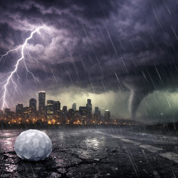
Kenosha and nearby parts of southern Wisconsin are facing a stretch of severe storms that could bring tornadoes, destructive winds, large hail and flash flooding. Forecasters say the main threat may shift from round to round, making alerts and shelter plans essential.
tornado warningtornado kenoshaKenosha severe stormsdestructive windslarge hailflash floodingsouthern Wisconsin weather

Kenosha is in the zone of concern as a severe weather pattern brings the risk of tornadoes, damaging winds, large hail and heavy rain across southern Wisconsin. The forecast calls for multiple rounds of storms over roughly 48 hours, which means conditions can change quickly and the most dangerous window may not be the same from one community to the next.
The main concern is not just one storm line, but several chances for severe weather to organize, strengthen and move through the region. In similar setups, a warm and unstable air mass can fuel thunderstorms that intensify fast, especially when strong winds aloft line up with enough moisture at the surface. That combination can support supercells, bowing segments and embedded tornadoes, along with wind damage and hail large enough to break windows and damage roofs and vehicles.
For Kenosha, the practical message is simple: do not wait for the sky to look especially threatening before taking the forecast seriously. Tornadoes can form with limited warning, and severe thunderstorm warnings can include destructive wind tags when gusts are expected to reach extreme levels. Those alerts are designed to trigger sirens and cell phone warnings, but the responsibility still falls on residents to move quickly to shelter when the warning is issued.
The threat is especially concerning because the storms may arrive in waves. One round may mainly produce rain and lightning, while the next brings the stronger wind and tornado risk. That kind of setup can create a false sense of security if the first storms are not severe in a particular neighborhood. A quiet stretch between rounds does not mean the danger is over.
People in homes without basements should identify a small interior room on the lowest floor ahead of time. Bathrooms, closets and hallways away from windows are often the best option. If there is a basement, that is usually the safest place to go during a tornado warning. Mobile homes, vehicles and open outdoor areas are especially dangerous during tornado conditions and should not be treated as shelter.
The severe weather threat also comes with the possibility of flash flooding. Repeated storms can dump enough rain in a short period to overwhelm drains, flood low-lying roads and make travel hazardous. Even if the strongest wind and hail stay just outside Kenosha, heavy rain can still create problems for commuters, emergency response and anyone trying to move between storm cells.
The human side of severe weather can be easy to overlook until a warning is already in effect. One account from the storm zone described a postal worker still trying to finish deliveries while winds were strong enough to shake a van and send debris through the air. That kind of scene captures how quickly ordinary routines can clash with a dangerous weather emergency. In severe storms, work schedules, errands and package deliveries all need to give way to safety.
That is especially true when alerts mention tornadoes or destructive winds. No delivery, appointment or task is worth staying outside for. If a warning is issued, anyone in the path of the storm should stop what they are doing, move away from windows and get into the best available shelter immediately. Waiting to see whether the storm gets worse can be the wrong choice when the atmosphere is already capable of producing violent weather.
Forecast guidance has pointed to an enhanced severe risk across parts of the Upper Midwest, including southern Wisconsin. That does not mean every town will see a tornado, but it does mean the atmosphere is primed for storms that can turn dangerous fast. The exact timing, track and intensity of each round may still shift, which is why local updates matter through the day and into the evening.
For residents of Kenosha, preparedness should start before the first warning siren sounds. Charge phones, review where to shelter, keep shoes and a flashlight nearby, and make sure weather alerts are enabled. If you live with children, older adults or pets, think through how you will move everyone quickly if a warning is issued at night or during a busy part of the day.
Businesses, schools and community buildings should also be ready to act. Large public spaces need a plan for moving people away from glass and into interior shelter areas. Staff members should know who is responsible for monitoring alerts and who will make the call to move people to safety. In severe weather, hesitation can be costly.
The broader pattern across the region suggests that the next day or two could be active, with storms capable of producing damaging winds, hail and isolated tornadoes. For Kenosha, that means staying alert to every update rather than assuming the risk has passed after the first round. Severe weather often arrives in pieces, and the most dangerous storm may be the one that forms after a brief lull.
When severe storms threaten tornado Kenosha, the safest approach is to treat the forecast as real and the warning as immediate. Move early, shelter fast and stay put until officials say the danger has passed. In a setup like this, caution is not overreaction. It is the right response to a weather pattern that can turn severe in minutes.